
Tropical Depression #EntengPH
Issued at 5:00 PM, 01 September 2024
Valid for broadcast until the next bulletin at 8:00 PM today.
“𝗘𝗡𝗧𝗘𝗡𝗚” 𝗦𝗟𝗜𝗚𝗛𝗧𝗟𝗬 𝗜𝗡𝗧𝗘𝗡𝗦𝗜𝗙𝗜𝗘𝗦 𝗢𝗩𝗘𝗥 𝗧𝗛𝗘 𝗪𝗔𝗧𝗘𝗥𝗦 𝗡𝗢𝗥𝗧𝗛𝗘𝗔𝗦𝗧 𝗢𝗙 𝗡𝗢𝗥𝗧𝗛𝗘𝗥𝗡 𝗦𝗔𝗠𝗔𝗥.
Location of Center (4:00 PM):
The center of Tropical Depression ENTENG was estimated based on all available data at 100 km Northeast of Catarman, Northern Samar or 115 km East Southeast of Virac, Catanduanes (13.2°N, 125.2°E)

𝗜𝗻𝘁𝗲𝗻𝘀𝗶𝘁𝘆:
Maximum sustained winds of 55 km/h near the center, gustiness of up to 70 km/h, and central pressure of 1000 hPa
𝗣𝗿𝗲𝘀𝗲𝗻𝘁 𝗠𝗼𝘃𝗲𝗺𝗲𝗻𝘁:
Northwestward at 15 km/h
Extent of Tropical Cyclone Winds:
Strong winds extend outwards up to 200 km from the center
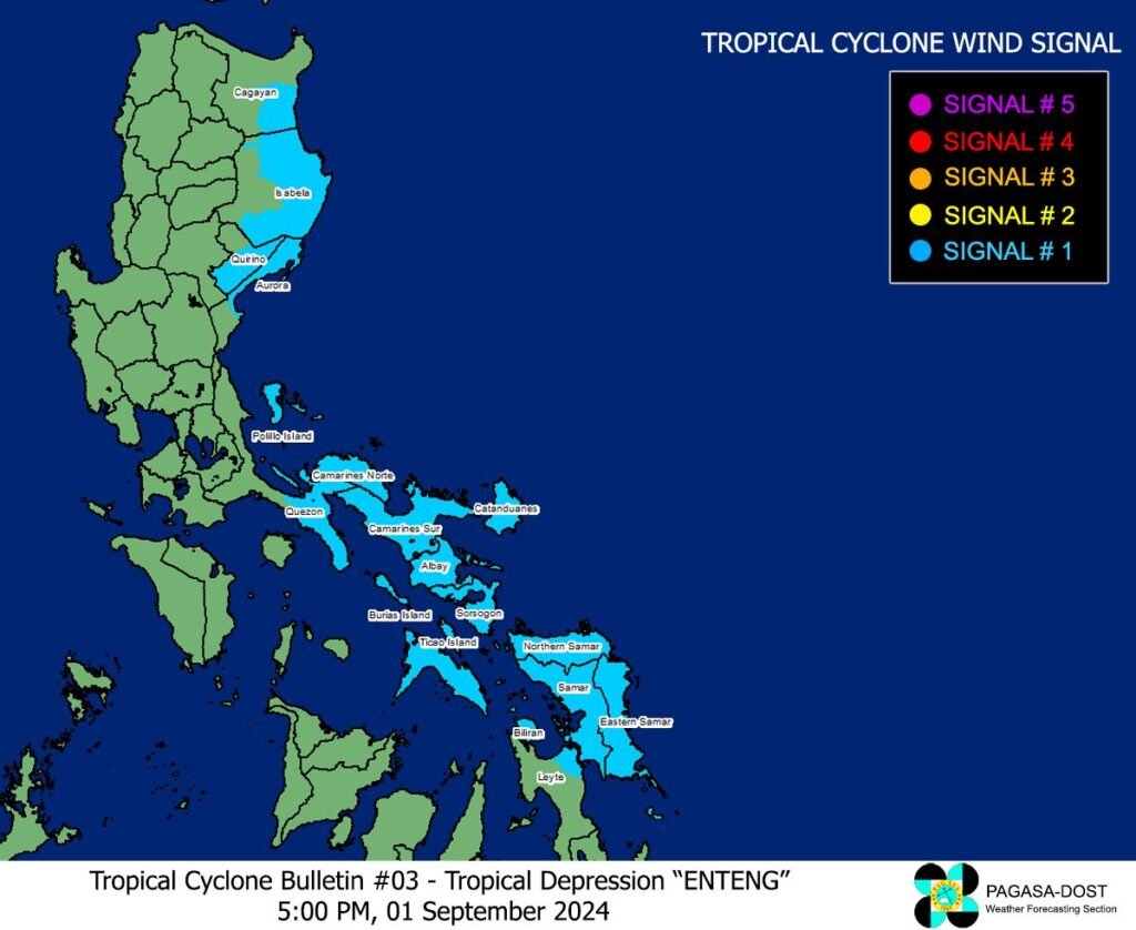
TROPICAL CYCLONE WIND SIGNALS (TCWS) IN EFFECT
𝗧𝗖𝗪𝗦 𝗡𝗼. 𝟭 𝗪𝗶𝗻𝗱 𝘁𝗵𝗿𝗲𝗮𝘁: 𝗦𝘁𝗿𝗼𝗻𝗴 𝘄𝗶𝗻𝗱𝘀
Luzon
The southeastern portion of Cagayan (Baggao, Peñablanca), the eastern portion of Isabela (Palanan, Dinapigue, Divilacan, San Agustin, San Guillermo, Jones, Echague, San Mariano, Maconacon, San Pablo, Cabagan, Tumauini, Ilagan City), the southern portion of Quirino (Nagtipunan, Maddela), the northern portion of Aurora (Dilasag, Casiguran, Dinalungan, Dipaculao, Baler), Polillo Islands, the southern portion of mainland Quezon (Tagkawayan, Guinayangan, Buenavista, San Narciso, Mulanay, San Andres, San Francisco, Lopez, Calauag, Catanauan, Gumaca, Macalelon, General Luna, Quezon, Alabat, Perez), Camarines Norte, Camarines Sur, Catanduanes, Albay, Sorsogon, and Masbate incuding Ticao and Burias Islands
𝗩𝗶𝘀𝗮𝘆𝗮𝘀
Northern Samar, Samar, Eastern Samar, Biliran, and the northeastern portion of Leyte (Babatngon, San Miguel, Tacloban City, Alangalang, Santa Fe, Palo, Barugo)
Warning lead time: 36 hours
Range of wind speeds: 39 to 61 km/h (Beaufort 6 to 7)
Potential impacts of winds: Minimal to minor threat to life and property
OTHER HAZARDS AFFECTING LAND AREAS
𝗛𝗲𝗮𝘃𝘆 𝗥𝗮𝗶𝗻𝗳𝗮𝗹𝗹 𝗢𝘂𝘁𝗹𝗼𝗼𝗸
Forecast accumulated rainfall: Today to tomorrow afternoon (2 September)
- 100-200 mm: Polillo Islands, Catanduanes, Camarines Norte, Camarines Sur, Masbate, Albay, Sorsogon, Northern Samar, and Samar
- 50-100 mm: Metro Manila, the rest of CALABARZON, Marinduque, Romblon, Eastern Samar, Biliran, and the northern portion of Leyte.
Forecast accumulated rainfall: Tomorrow afternoon to Tuesday afternoon (3 September) - 100-200 mm: Isabela, Cagayan, Abra, Ilocos Norte
- 50-100 mm: Aurora and the rest of Ilocos Region, Cordillera Administrative Region, and mainland Cagayan Valley
Forecast accumulated rainfall: Tuesday afternoon to Wednesday afternoon (4 September) - 100-200 mm: Babuyan Islands, Apayao, Ilocos Norte, and the northern portion of Ilocos Sur
- 50-100 mm: Batanes, mainland Cagayan, and the rest of Cordillera Administrative Region and Ilocos Region.
Forecast rainfall are generally higher in elevated or mountainous areas. Under these conditions, flooding and rain-induced landslides are likely especially in areas that are highly or very highly susceptible to these hazards as identified in official hazard maps and in localities that experienced considerable amounts of rainfall for the past several days.
Furthermore, the enhanced Southwest Monsoon will bring moderate to intense rainfall in other areas of Luzon and Visayas (especially along the western portions). For more information, refer to Weather Advisory No. 3 issued at 11:00 AM today.
𝗦𝗲𝘃𝗲𝗿𝗲 𝗪𝗶𝗻𝗱𝘀
The wind signals warn the public of the general wind threat over an area due to the tropical cyclone. Local winds may be slightly stronger/enhanced in coastal and upland/mountainous areas exposed to winds. Winds are less strong in areas sheltered from the prevailing wind direction.
- Minimal to minor impacts from strong winds are possible within any of the areas under Wind Signal No. 1.
The highest possible Wind Signal that may be hoisted during the passage of ENTENG is Wind Signal No. 2 or 3.
The enhanced Southwest Monsoon will also bring strong to gale-force gusts over the following areas (especially in coastal and upland areas exposed to winds): - From today to tomorrow afternoon: MIMAROPA, Western Visayas, Central Visayas, Negros Island Region, Eastern Visayas (outside Wind Signal areas), Caraga Region, Northern Mindanao, and Zamboanga Peninsula
- From tomorrow afternoon to Tuesday afternoon: Zambales, Bataan, Aurora, Bulacan, Metro Manila, CALABARZON, MIMAROPA, Bicol Region, Visayas, and Caraga Region.
- From Tuesday afternoon to Wednesday afternoon: Zambales, Bataan, Aurora, Bulacan, Metro Manila, CALABARZON, MIMAROPA, Bicol Region, and Western Visayas.
𝗛𝗔𝗭𝗔𝗥𝗗𝗦 𝗔𝗙𝗙𝗘𝗖𝗧𝗜𝗡𝗚 𝗖𝗢𝗔𝗦𝗧𝗔𝗟 𝗪𝗔𝗧𝗘𝗥𝗦
In the next 24 hours, ENTENG and the enhanced Southwest Monsoon will bring the following conditions over the coastal waters of the country:
- Gale Warning is in effect over Catanduanes, Camarines Norte, the eastern coast of Camarines Sur, the eastern coast of Albay, the eastern coast of Sorsogon, and the northern and eastern coast of Northern Samar. Sea travel is risky for small seacrafts, including all types of motorbancas. For more information, refer to Gale Warning No. 1 issued at 5:00 PM today.
- Moderate to rough seas over the eastern seaboards of Central Luzon and Southern Luzon outside Gale Warning areas (1.5 to 3.5 m), the eastern seaboard of Eastern Samar, and the seaboard of Kalayaan Islands (1.5 to 3.0 m). Mariners of small seacrafts, including all types of motorbancas, are advised not to venture out to sea under these conditions, especially if inexperienced or operating ill-equipped vessels.
- Moderate seas are expected over the southern seaboard of CALABARZON, the remaining seaboards of Bicol Region, Palawan, and Eastern Visayas, the seaboard of Western Visayas, the northern and eastern seaboard of Caraga Region, and the eastern seaboard of Davao Oriental (1.5 to 2.5 m). Slight to moderate seas are possible for the eastern seaboard of mainland Northern Luzon, the remaining seaboards of MIMAROPA, Visayas, and Caraga Region, the seaboard of Northern Mindanao, the eastern seaboard of Davao Occidental (1.0 to 2.0 m). Mariners of motorbancas and similarly sized vessels are advised to take precautionary measures while venturing out to sea and, if possible, avoid navigation under these conditions.
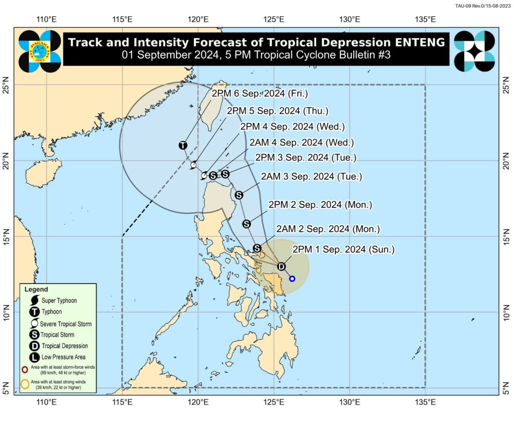
𝗧𝗥𝗔𝗖𝗞 𝗔𝗡𝗗 𝗜𝗡𝗧𝗘𝗡𝗦𝗜𝗧𝗬 𝗢𝗨𝗧𝗟𝗢𝗢𝗞
- ENTENG is forecast to move generally northwestward until tomorrow (2 September) early morning and may make landfall in the vicinity of Catanduanes or Albay in the next 12 hours. For the remainder of tomorrow, ENTENG will turn more north northwestward or northward after emerging over the waters north of Camarines Provinces and move over the waters east of Luzon. From Tuesday (3 September) to Wednesday (4 September), ENTENG is forecast to turn northwestward initially, then westward while decelerating over the Luzon Strait. Another landfall in the vicinity of mainland Northern Luzon or Babuyan Islands is not ruled out. A more northwestward movement is expected by Thursday (5 September) onwards.
- ENTENG is forecast to reach tropical storm category within the next 12 hours. It is forecast to remain at this category until early Wednesday. It may also reach a peak category of typhoon by Thursday or Friday.
Considering these developments, the public and disaster risk reduction and management offices concerned are advised to take all necessary measures to protect life and property. Persons living in areas identified to be highly or very highly susceptible to these hazards are advised to follow evacuation and other instructions from local officials. For heavy rainfall warnings, thunderstorm/rainfall advisories, and other severe weather information specific to your area, please monitor products issued by your local PAGASA Regional Services Division.
The next tropical cyclone bulletin will be issued at 8:00 PM today.
DOST-PAGASA