Tropical Depression #GenerPH
Issued at 8:00 PM, 16 September 2024
Valid for broadcast until the next bulletin at 11:00 PM today.
“GENER” SLIGHTLY ACCELERATES TOWARDS NORTHERN LUZON MAINLAND.
- Location of Center (7:00 PM)
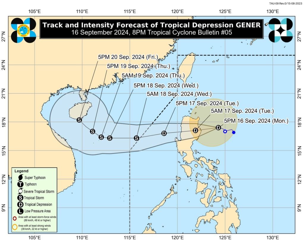
The center of Tropical Depression GENER was estimated based on all available data at 240 km East of Tuguegarao City, Cagayan (17.5°N, 124.0°E) - Intensity
Maximum sustained winds of 55 km/h near the center, gustiness of up to 70 km/h, and central pressure of 996 hPa - Present Movement
West northwestward at 15 km/h - Extent of Tropical Cyclone Winds
Strong winds extend outwards up to 360 km from the center
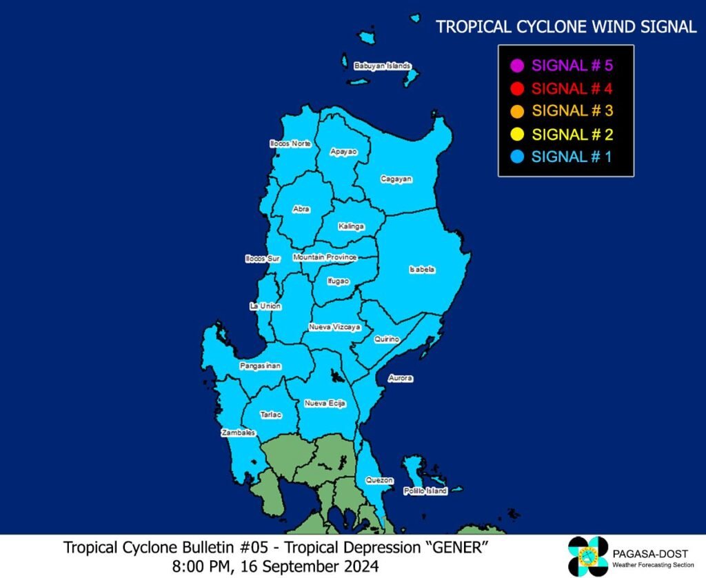
𝗧𝗥𝗢𝗣𝗜𝗖𝗔𝗟 𝗖𝗬𝗖𝗟𝗢𝗡𝗘 𝗪𝗜𝗡𝗗 𝗦𝗜𝗚𝗡𝗔𝗟𝗦 (𝗧𝗖𝗪𝗦) 𝗜𝗡 𝗘𝗙𝗙𝗘𝗖𝗧
- 𝗧𝗖𝗪𝗦 𝗡𝗼. 𝟭
○ Wind threat: Strong winds
○ Warning lead time: 36 hours
○ Range of wind speeds: 39 to 61 km/h (Beaufort 6 to 7)
○ Potential impacts of winds: Minimal to minor threat to life and property
LUZON:
Cagayan including Babuyan Islands, Isabela, Quirino, Nueva Vizcaya, Apayao, Kalinga, Abra, Ifugao, Mountain Province, Benguet, Ilocos Norte, Ilocos Sur, La Union, Pangasinan, Zambales, Tarlac, Nueva Ecija, Aurora, and the northern portion of Quezon (General Nakar, Infanta, Real) including Polillo Islands
OTHER HAZARDS AFFECTING LAND AREAS
Heavy Rainfall Outlook
Refer to Weather Advisory No. 22 issued at 8:00 PM today for the heavy rainfall outlook due to Tropical Depression GENER and the Southwest Monsoon enhanced by GENER and Tropical Storm PULASAN.
Severe Winds
The wind signals warn the public of the general wind threat over an area due to the tropical cyclone. Local winds may be slightly stronger/enhanced in coastal and upland/mountainous areas exposed to winds. Winds are less strong in areas sheltered from the prevailing wind direction.
- Minimal to minor impacts from strong winds are possible within any of the areas under Wind Signal No. 1.
The Southwest Monsoon enhanced by GENER and “PULASAN” will also bring strong to gale-force gusts over the following areas (especially in coastal and upland areas exposed to winds): - Today: Batanes, MIMAROPA, Bicol Region, Visayas, Zamboanga Peninsula, Northern Mindanao, Caraga Region, and Davao Region.
- Tomorrow (17 September): Batanes, MIMAROPA, Bicol Region, Visayas, and Mindanao.
- Wednesday (18 September): Zambales, Bataan, Pampanga, Bulacan, Metro Manila, CALABARZON, MIMAROPA, Bicol Region, Visayas, and Mindanao.
HAZARDS AFFECTING COASTAL WATERS
24-Hour Sea Condition Outlook
Gale Warning is in effect over several coastal waters in the western and southern seaboards of Southern Luzon, the seaboards of Visayas, and the western, northern, and eastern seaboards of Mindanao. For more information, refer to Gale Warning No. 5 issued at 5:00 PM today. Sea travel in these waters is risky for small seacrafts, including all types of motorbancas.
Up to rough seas over the following coastal waters:
- 1.5 to 3.5 m: Batanes, Babuyan Islands, and the northern seaboards of Ilocos Region and Cagayan Valley
- 1.5 to 3.0 m: The eastern seaboard of Bicol Region, the seaboard of Visayas outside Gale Warning areas, and the eastern seaboards of Caraga Region and Davao Region.
- Mariners of small seacrafts, including all types of motorbancas, are advised not to venture out to sea under these conditions, especially if inexperienced or operating ill-equipped vessels.
Up to moderate seas over the following coastal waters:
- Up to 2.5 m: The remaining seaboards of the country outside Gale Warning areas.
- Mariners of small seacrafts, including all types of motorbancas, are advised not to venture out to sea under these conditions.
TRACK AND INTENSITY OUTLOOK
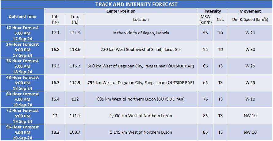
- GENER is forecast to make landfall in the vicinity of Isabela or Aurora tonight or tomorrow morning and may likely emerge over the coastal waters of La Union or Pangasinan tomorrow (17 September) late morning or afternoon. The tropical cyclone will then move generally westward over the West Philippine Sea until Wednesday (18 September) before turning northwestward on Thursday (19 September) as it heads towards southern mainland China.
- GENER may exit the Philippine Area of Responsibility (PAR) between tomorrow late evening and Wednesday morning.
- GENER will likely cross the landmass of mainland Luzon as a tropical depression, although the possibility of reaching tropical storm category or slight weakening prior to landfall is not ruled out. Over the West Philippine Sea, GENER may reach tropical storm category tomorrow evening or on Wednesday morning.
Considering these developments, the public and disaster risk reduction and management offices concerned are advised to take all necessary measures to protect life and property. Persons living in areas identified to be highly or very highly susceptible to these hazards are advised to follow evacuation and other instructions from local officials. For heavy rainfall warnings, thunderstorm/rainfall advisories, and other severe weather information specific to your area, please monitor products issued by your local PAGASA Regional Services Division.
The next tropical cyclone bulletin will be issued at 11:00 PM today.
DOST-PAGASA
Link: tinyurl.com/tcgener


