The provincial government of Zambales will monitor and review ongoing developments located in coastal areas and identified hazard zones to ensure the safety of residents and local communities in disaster-prone locations.
This was announced by Governor Hermogenes E. Ebdane Jr. over the weekend following an assessment by the Inter-Agency Committee (IAC) of coastal hazards in the province, particularly incidents of coastal erosion during heavy monsoon rains induced by Typhoon Carina.
“We have deemed it best not to allow further developments — whether for residential or recreational purposes — in areas that are hazard-prone. This is in consideration of public safety, which should be our paramount concern,” Ebdane said.
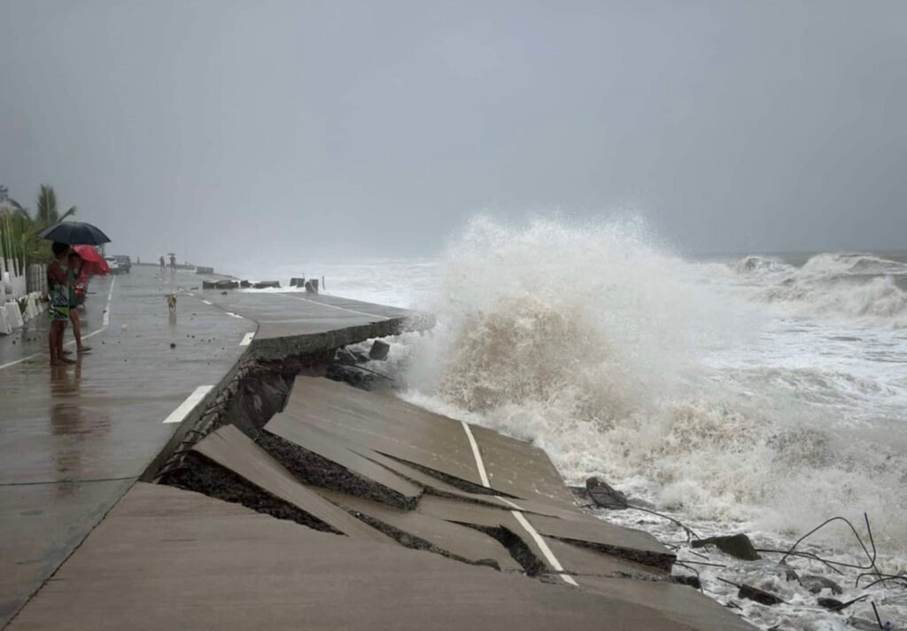
Ebdane cited as an example Sitio Tektek at Barangay Sindol in San Felipe, Zambales, where a storm surge destroyed a large portion of the coastal road and protective dike at the height of Typhoon Carina.
According to a report by the IAC-Technical Working Group (TWG), Sitio Tektek, as well as Sitio Laoag in nearby Barangay Maloma have “moderate vulnerability” to coastal hazards like flooding.
The IAC-TWG recently made a coastal hazards vulnerability assessment in San Felipe with the Mines and Geosciences Bureau of the Department of Environment and Natural Resources (DENR-MGB), Provincial Disaster Risk Reduction and Management Office (PDRRMO), Provincial Engineering Office (PEO), and local barangay officials.
Engineer Domingo L. Mariano, who heads the IAC-TWG, pointed out that Tektek and Laoag have experienced coastal accretion over the years from 20026 to 2020, with a maximum width ranging from 250 meters to 350 meters.
He said that accretion was primarily observed south of Maloma River, with a maximum increase of 114 meters at an average rate of 18.8 meters per year. On the other hand, erosion was more evident north of Maloma River, with a maximum rate of 16.5 meters per year and a 100-meter eroded width, Mariano added.
Coastal accretion is the process of growth or increase, typically by the gradual accumulation of additional layers of materials. In the case of Tektek and Laoag, accretion consisted of Mt. Pinatubo debris that washed down the nearby Maloma River.
“This coastal zone (along Tektek and Laoag) is dynamic, experiencing cycles of coastal erosion and accretion. Hence, MGB recommended that these areas be designated as a ‘No Habitation Zone’ in its monitoring report on shoreline shift in Maloma River in October 2021,” Mariano said.
In its July 26 report to Gov. Ebdane, the IAC-TWG recommended the following: (1) To discourage further development of residential and recreational areas along the coast; (2) To designate potential evacuation sites that are situated on higher ground and safe from maximum storm surges and tsunamis; (3) To increase the level of awareness and preparedness of the residents; (4) To follow storm surge and tsunami alerts; and (5) To conduct continuous shoreline monitoring to detect and address signs of erosion, particularly in residential areas.
Residents of Tektek and Laoag are mostly fisherfolk engaged in marginal fishing for their livelihood.
While the erosion of the coastal road was among the major damages to infrastructures recorded in Zambales during Typhoon Carina, the PDRRMO reported only two families composed of eight individuals from Maloma as having evacuated at the height of the recent weather disturbance.
In all, the evacuees throughout Zambales during Typhoon Carina consisted of 2,139 families composed of 6,128 individuals, the PDRRMO said. (30)
PHOTO:
𝑆𝑡𝑜𝑟𝑚 𝑠𝑢𝑟𝑔𝑒 𝑑𝑒𝑠𝑡𝑟𝑜𝑦 𝑎 𝑝𝑜𝑟𝑡𝑖𝑜𝑛 𝑜𝑓 𝑡ℎ𝑒 𝑐𝑜𝑎𝑠𝑡𝑎𝑙 𝑟𝑜𝑎𝑑 𝑎𝑡 𝑆𝑖𝑡𝑖𝑜 𝑇𝑒𝑘𝑡𝑒𝑘, 𝑎𝑛 𝑎𝑟𝑒𝑎 𝑖𝑑𝑒𝑛𝑡𝑖𝑓𝑖𝑒𝑑 𝑎𝑠 𝑎 𝑑𝑦𝑛𝑎𝑚𝑖𝑐 𝑧𝑜𝑛𝑒 𝑤ℎ𝑒𝑟𝑒 𝑐𝑜𝑎𝑠𝑡𝑎𝑙 𝑎𝑐𝑐𝑟𝑒𝑡𝑖𝑜𝑛 𝑎𝑛𝑑 𝑒𝑟𝑜𝑠𝑖𝑜𝑛 𝑜𝑐𝑐𝑢𝑟 𝑖𝑛 𝑐𝑦𝑐𝑙𝑒𝑠. (PDRRMO photo)


