Tropical Storm #CarinaPH (GAEMI)
Issued at 11:00 AM, 21 July 2024
Valid for broadcast until the next bulletin at 5:00 PM today.
TROPICAL STORM “CARINA” SLIGHTLY INTENSIFIES OVER THE PHILIPPINE SEA.
- Location of Center (10:00 AM)
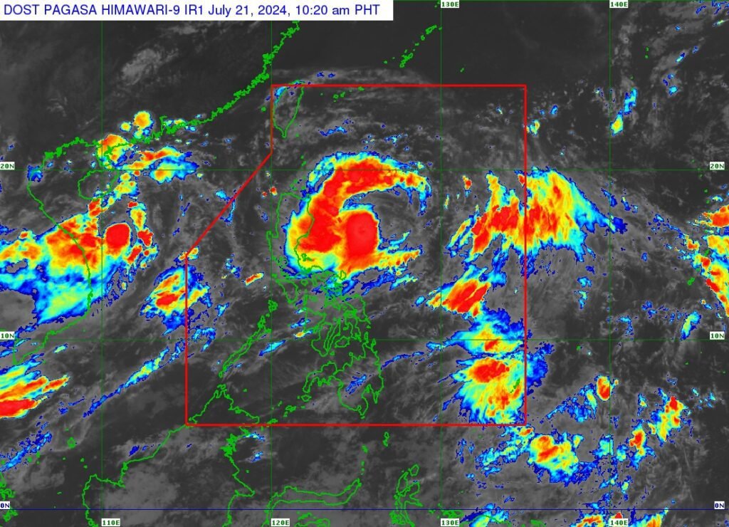
The center of Tropical Storm CARINA was estimated based on all available data at 350 km East of Casiguran, Aurora (16.4°N, 125.4°E) - Intensity
Maximum sustained winds of 85 km/h near the center, gustiness of up to 115 km/h, and central pressure of 996 hPa - Present Movement
Westward at 20 km/h - Extent of Tropical Cyclone Winds
Strong to gale-force winds extend outwards up to 320 km from the center
TROPICAL CYCLONE WIND SIGNALS (TCWS) IN EFFECT
No Wind Signal hoisted at this time.
OTHER HAZARDS AFFECTING LAND AREAS
Heavy Rainfall Outlook
Forecast accumulated rainfall: Today to Tomorrow noon (22 July)
- 50-100 mm: Mainland Cagayan and Babuyan Islands
Forecast accumulated rainfall: Tomorrow noon to Tuesday noon (23 July)
- 100-200 mm: Batanes
- 50-100 mm: Babuyan Islands and mainland Cagayan
Forecast accumulated rainfall: Tuesday noon (23 July) to Wednesday noon (24 July)
- 100-200 mm: Batanes
- 50-100 mm: Babuyan Islands
Forecast rainfall are generally higher in elevated or mountainous areas. Under these conditions, flooding and rain-induced landslides are possible especially in areas that are highly or very highly susceptible to these hazards as identified in official hazard maps and in localities that experienced considerable amounts of rainfall for the past several days.
Furthermore, the enhanced Southwest Monsoon will bring moderate to intense rainfall over various localities in the western portion of Luzon tomorrow through Tuesday. For more information, refer to Weather Advisory No. 23 issued at 11:00 AM today.
Severe Winds
The hoisting of Wind Signal No. 1 over Extreme Northern Luzon and northeastern portion of mainland Cagayan is not ruled out, possibly by tonight or tomorrow in anticipation of strong winds associated with CARINA.
The Southwest Monsoon that will be enhanced by CARINA and Tropical Depression (formerly BUTCHOY) will bring strong to gale-force gusts over the following areas (especially in coastal and upland areas exposed to winds):
- From today (21 July) to tomorrow noon (22 July): MIMAROPA, Bicol Region, and Western Visayas
- From tomorrow noon (22 July) to Tuesday noon (23 July): Zambales, Bataan, Metro Manila, CALABARZON, MIMAROPA, Bicol Region, and Visayas
- From Tuesday noon (23 July) to Wednesday noon (24 July): Ilocos Region, Central Luzon, Metro Manila, CALABARZON, MIMAROPA, Bicol Region, and Visayas.
HAZARDS AFFECTING COASTAL WATERS
In the next 24 hours, CARINA and the enhanced Southwest Monsoon will bring moderate seas over the coastal waters along the northern seaboard of Northern Luzon (1.0-2.5 m), the western seaboards of Central and Southern Luzon (1.5-2.5 m), and the eastern seaboard of the country (1.0-2.5 m).
Mariners of motorbancas and similarly-sized vessels are advised to take precautionary measures while venturing out to sea and, if possible, avoid navigation under these conditions.
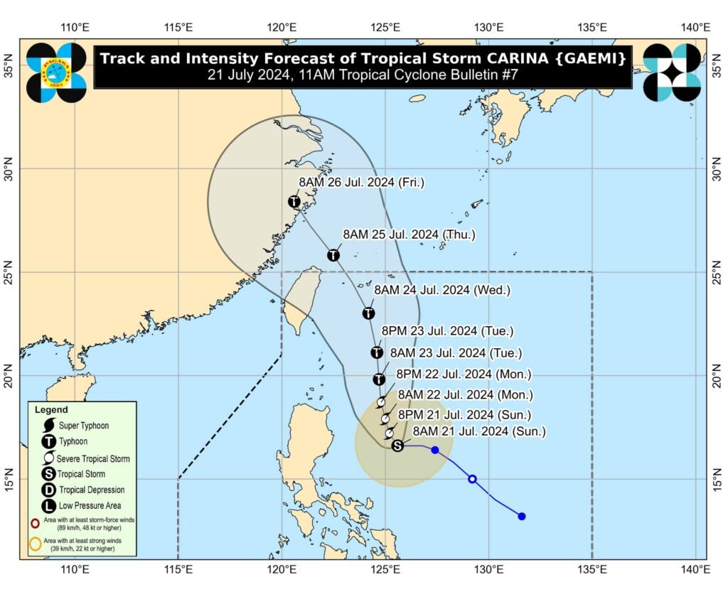
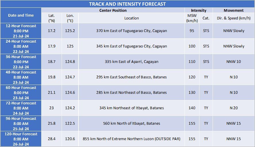
TRACK AND INTENSITY OUTLOOK
- Over the Philippine Sea, CARINA is forecast to move generally north northwestward to northward from today until Tuesday (23 July). On the track forecast, CARINA will remain far from the Philippine landmass and exit the Philippine Area of Responsibility on Wednesday night (24 July) or Thursday early morning (25 July) while moving near the islands in the Ryukyu archipelago. Outside the PAR, CARINA will turn generally northwestward on Thursday (25 July) over the East China Sea, passing near or over Senkaku Islands.
- CARINA is forecast to steadily intensify over the next four days due to favorable environment. It is forecast to become a severe tropical storm by tonight and reach typhoon category tomorrow evening. Rapid intensification within the forecast period is possible.
Considering these developments, the public and disaster risk reduction and management offices concerned are advised to take all necessary measures to protect life and property. Persons living in areas identified to be highly or very highly susceptible to these hazards are advised to follow evacuation and other instructions from local officials. For heavy rainfall warnings, thunderstorm/rainfall advisories, and other severe weather information specific to your area, please monitor products issued by your local
PAGASA Regional Services Division.
The next tropical cyclone bulletin will be issued at 5:00 PM today.
DOST-PAGASA