


Tropical Storm #DindoPH (JONGDARI)
Issued at 11:00 AM, 19 August 2024
TROPICAL STORM “DINDO” HAS EXITED THE PHILIPPINE AREA OF RESPONSIBILITY.
- Location of Center (10:00 AM)
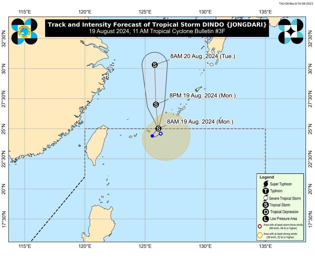
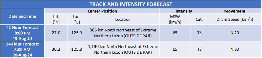
The center of Tropical Storm DINDO was estimated based on all available data at 670 km Northeast of Itbayat, Batanes (OUTSIDE PAR) (25.3°N, 126.2°E) - Intensity
Maximum sustained winds of 65 km/h near the center, gustiness of up to 80km/h, and central pressure of 1000 hPa - Present Movement
Northeastward slowly - Extent of Tropical Cyclone Winds
Strong to gale-force winds extend outwards up to 320 km from the center
TROPICAL CYCLONE WIND SIGNALS (TCWS) IN EFFECT
No Wind Signal hoisted at this time.
OTHER HAZARDS AFFECTING LAND AREAS
DINDO is unlikely to directly affect the weather condition in the country within the forecast period.
HAZARDS AFFECTING COASTAL WATERS
DINDO and the Southwest Monsoon will bring moderate seas (1.0-2.0 m) over the coastal waters of Extreme Northern Luzon. Mariners of motor bancas and similarly sized vessels are advised to take precautionary measures while venturing out to sea and, if possible, avoid navigating in these conditions, especially if inexperienced or operating ill-equipped vessels.
TRACK AND INTENSITY OUTLOOK
- Over the next three days, DINDO is forecast to move over the East China Sea and Yellow sea towards the Korean Peninsula.
- DINDO will likely remain as a tropical storm within the forecast period.
Considering these developments, the public and disaster risk reduction and management offices concerned are advised to take all necessary measures to protect life and property. Persons living in areas identified to be highly or very highly susceptible to these hazards are advised to follow evacuation and other instructions from local officials. For heavy rainfall warnings, thunderstorm/rainfall advisories, and other severe weather information specific to your area, please monitor products issued by your local PAGASA Regional Services Division.
Unless re-entry occurs, this is the final tropical cyclone bulletin. Further updates will be provided in the 24-Hour Public Weather Forecast to be issued at 4:00 AM and 4:00 PM daily.
DOST-PAGASA