
Typhoon #AghonPH (EWINIAR)
Issued at 8:00 AM, 27 May 2024
Valid for broadcast until the next bulletin at 11:00 AM today.
TYPHOON “AGHON” CONTINUES TO MOVE NORTHEASTWARD OVER THE PHILIPPINE SEA EAST OF AURORA PROVINCE.
Location of Center (7:00 AM): The center of the eye of Typhoon AGHON was estimated based on all available data including those from Baler and Daet Doppler Weather Radars over the coastal waters of Casiguran, Aurora (15.8°N, 122.8°E)
Intensity: Maximum sustained winds of 140 km/h near the center, gustiness of up to 170 km/h, and central pressure of 965 hPa
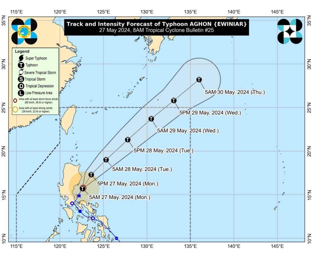

Present Movement: North Northeastward at 10 km/h
Extent of Tropical Cyclone Winds: Strong to typhoon-force winds extend outwards up to 220 km from the center
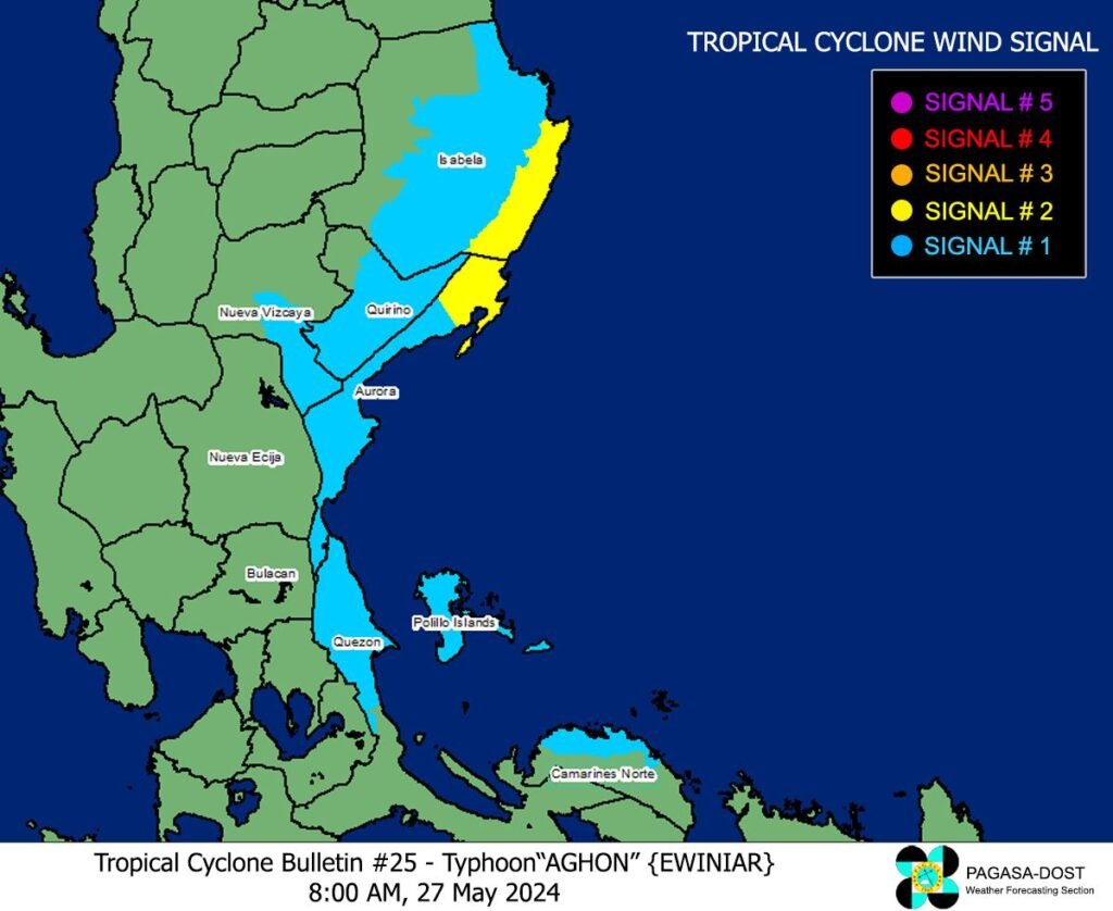
TROPICAL CYCLONE WIND SIGNALS (TCWS) IN EFFECT
TCWS No. 2
Wind threat: Gale-force winds
Luzon
The southeastern portion of Isabela (Dinapigue, Palanan), and the northern portion of Aurora (Dilasag, Casiguran)
Warning lead time: 24 hours
Range of wind speeds: 62 to 88 km/h (Beaufort 8 to 9)
Potential impacts of winds: Minor to moderate threat to life and property
TCWS No. 1
Wind threat: Strong winds
Luzon
The northeastern and southern portion of Isabela (Divilacan, San Mariano, San Guillermo, Jones, Echague, San Agustin, Ilagan City, Benito Soliven, City of Cauayan, Maconacon, Angadanan, Naguilian), the eastern portion of Quirino (Maddela, Nagtipunan, Aglipay), the southern portion of Nueva Vizcaya (Alfonso Castaneda), the rest of Aurora, the northern portion of Quezon (General Nakar, Infanta, Real) including Polillo Islands, and the northwestern portion of Camarines Norte (Paracale, Jose Panganiban, Vinzons, Capalonga) including Calaguas Islands
Warning lead time: 36 hours
Range of wind speeds: 39 to 61 km/h (Beaufort 6 to 7)
Potential impacts of winds: Minimal to minor threat to life and property
HAZARDS AFFECTING LAND AREAS
Heavy Rainfall Outlook
- Typhoon AGHON is less likely to directly bring significant amount of rainfall within the next three days.
- The Southwesterly Windflow enhanced by this typhoon will bring moderate to heavy rains over Western Visayas and portions of MIMAROPA in the next two days. For more information, refer to Weather Advisory No. 1 for Southwesterly Windflow issued at 8:00 AM today.
Severe Winds
The wind signals warn the public of the general wind threat over an area due to the tropical cyclone. Local winds may be slightly stronger/enhanced in coastal and upland/mountainous areas exposed to winds. Winds are less strong in areas sheltered from the prevailing wind direction.
- Minor to moderate impacts from gale-force winds are possible within any of the localities where Wind Signal No. 2 is hoisted.
- Minimal to minor impacts from strong winds are possible within any of the areas under Wind Signal No. 1.
HAZARDS AFFECTING COASTAL WATERS
- Under the influence of AGHON, a Gale Warning is hoisted over the coastal waters of Cagayan (southern portion), Isabela, Aurora, and the northern coastal waters of Quezon including Polillo Islands. Sea travel is risky for small seacrafts, including all motorbancas of any type of tonnage. For more information, refer to Gale Warning No. 4 issued at 5:00 AM today.
- Outside the Gale Warning areas, AGHON will bring moderate to rough seas (1.5 to 3.0 m) over the eastern coastal waters of Cagayan and the northern coastal waters of Bicol Region. Mariners of motor bancas and similarly-sized vessels are advised to take precautionary measures while venturing out to sea and, if possible, avoid navigating in these conditions, especially if inexperienced or operating ill-equipped vessels.
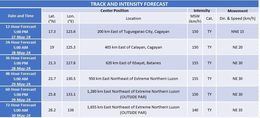
TRACK AND INTENSITY OUTLOOK
- On the track forecast, Typhoon AGHON will move generally northeastward over the Philippine Sea for the entirety of the forecast period. It may exit the Philippine Area of Responsibility (PAR) on Wednesday afternoon or evening as a typhoon.
- AGHON will continue to intensify over the next two days as it moves northeastward over the Philippine Sea. A weakening trend may begin on mid or late Wednesday as the typhoon begins interacting with the mid-latitude environment and undergo post-tropical transition.
Considering these developments, the public and disaster risk reduction and management offices concerned are advised to take all necessary measures to protect life and property. Persons living in areas identified to be highly or very highly susceptible to these hazards are advised to follow evacuation and other instructions from local officials. For heavy rainfall warnings, thunderstorm/rainfall advisories, and other severe weather information specific to your area, please monitor products issued by your local PAGASA Regional Services Division.
The next tropical cyclone bulletin will be issued at 11:00 AM today.