

Tropical Storm #DindoPH (JONGDARI)
Issued at 5:00 AM, 19 August 2024
Valid for broadcast until the next bulletin at 11:00 AM today.
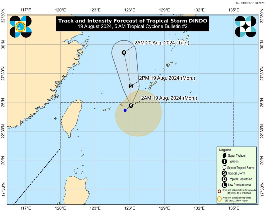
𝐓𝐑𝐎𝐏𝐈𝐂𝐀𝐋 𝐃𝐄𝐏𝐑𝐄𝐒𝐒𝐈𝐎𝐍 “𝐃𝐈𝐍𝐃𝐎” 𝐇𝐀𝐒 𝐈𝐍𝐓𝐄𝐍𝐒𝐈𝐅𝐈𝐄𝐃 𝐈𝐍𝐓𝐎 𝐀 𝐓𝐑𝐎𝐏𝐈𝐂𝐀𝐋 𝐒𝐓𝐎𝐑𝐌.
𝐋𝐨𝐜𝐚𝐭𝐢𝐨𝐧 𝐨𝐟 𝐂𝐞𝐧𝐭𝐞𝐫 (𝟒:𝟎𝟎 𝐀𝐌):
The center of Tropical Storm DINDO was estimated based on all available data at 640 km Northeast of Itbayat, Batanes (25.0°N, 126.1°E)
Intensity:
Maximum sustained winds of 65 km/h near the center, gustiness of up to 80km/h, and central pressure of 1000 hPa
Present Movement:
Northeastward at 10 km/h
Extent of Tropical Cyclone Winds:
Strong to gale-force winds extend outwards up to 320 km from the center
TROPICAL CYCLONE WIND SIGNALS (TCWS) IN EFFECT
No Wind Signal hoisted at this time.
OTHER HAZARDS AFFECTING LAND AREAS
DINDO is unlikely to directly affect the weather condition in the country within the forecast period.
HAZARDS AFFECTING COASTAL WATERS
DINDO and the Southwest Monsoon will bring moderate seas (1.0-2.0 m) over the coastal waters of Extreme Northern Luzon. Mariners of motor bancas and similarly sized vessels are advised to take precautionary measures while venturing out to sea and, if possible, avoid navigating in these conditions, especially if inexperienced or operating ill-equipped vessels.
TRACK AND INTENSITY OUTLOOK
- DINDO is forecast to move generally northward within the forecast period and exit the Philippine Area of Responsibility (PAR) within the next 6 hours. Outside the PAR region, DINDO will move over the East China Sea towards either the Korean Peninsula or the coast of eastern China.
- DINDO will likely remain as a tropical storm within the forecast period. Intensification will also be limited outside the PAR region, with a potential for a weakening trend beyond the next 24 hours.
Considering these developments, the public and disaster risk reduction and management offices concerned are advised to take all necessary measures to protect life and property. Persons living in areas identified to be highly or very highly susceptible to these hazards are advised to follow evacuation and other instructions from local officials. For heavy rainfall warnings, thunderstorm/rainfall advisories, and other severe weather information specific to your area, please monitor products issued by your local PAGASA Regional Services Division.
The next tropical cyclone bulletin will be issued at 11:00 AM today.
DOST-PAGASA