


𝐓𝐲𝐩𝐡𝐨𝐨𝐧 #𝐂𝐚𝐫𝐢𝐧𝐚𝐏𝐇 (𝐆𝐀𝐄𝐌𝐈)
𝐼𝑠𝑠𝑢𝑒𝑑 𝑎𝑡 11:00 𝐴𝑀, 25 𝐽𝑢𝑙𝑦 2024
𝑉𝑎𝑙𝑖𝑑 𝑓𝑜𝑟 𝑏𝑟𝑜𝑎𝑑𝑐𝑎𝑠𝑡 𝑢𝑛𝑡𝑖𝑙 𝑡ℎ𝑒 𝑛𝑒𝑥𝑡 𝑏𝑢𝑙𝑙𝑒𝑡𝑖𝑛 𝑎𝑡 5:00 𝑃𝑀 𝑡𝑜𝑑𝑎𝑦.
“𝐂𝐀𝐑𝐈𝐍𝐀” 𝐅𝐔𝐑𝐓𝐇𝐄𝐑 𝐖𝐄𝐀𝐊𝐄𝐍𝐒 𝐀𝐍𝐃 𝐈𝐒 𝐍𝐎𝐖 𝐎𝐔𝐓𝐒𝐈𝐃𝐄 𝐓𝐇𝐄 𝐏𝐇𝐈𝐋𝐈𝐏𝐏𝐈𝐍𝐄 𝐀𝐑𝐄𝐀 𝐎𝐅 𝐑𝐄𝐒𝐏𝐎𝐍𝐒𝐈𝐁𝐈𝐋𝐈𝐓𝐘 (𝐏𝐀𝐑).
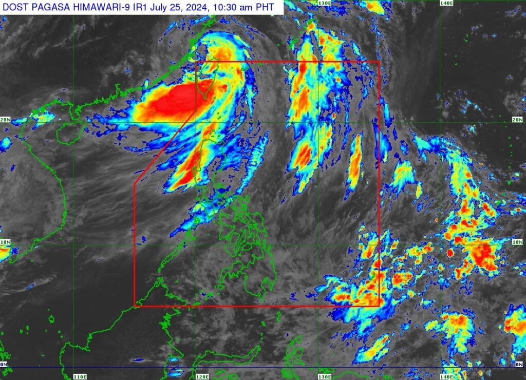
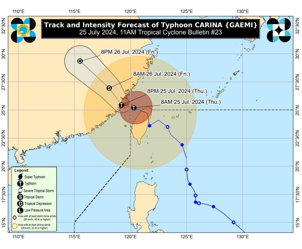
𝐋𝐨𝐜𝐚𝐭𝐢𝐨𝐧 𝐨𝐟 𝐂𝐞𝐧𝐭𝐞𝐫 (𝟏𝟎:𝟎𝟎 𝐀𝐌): The center of the eye of Typhoon CARINA was estimated based on all available data at 515 km North Northwest of Itbayat, Batanes (25.1°N, 120.0°E)
𝐈𝐧𝐭𝐞𝐧𝐬𝐢𝐭𝐲: Maximum sustained winds of 140 km/h near the center, gustiness of up to 215 km/h, and central pressure of 965 hPa
𝐏𝐫𝐞𝐬𝐞𝐧𝐭 𝐌𝐨𝐯𝐞𝐦𝐞𝐧𝐭: West Northwestward at 20 km/h
𝐄𝐱𝐭𝐞𝐧𝐭 𝐨𝐟 𝐓𝐫𝐨𝐩𝐢𝐜𝐚𝐥 𝐂𝐲𝐜𝐥𝐨𝐧𝐞 𝐖𝐢𝐧𝐝𝐬: Strong to typhoon-force winds extend outwards up to 640 km from the center
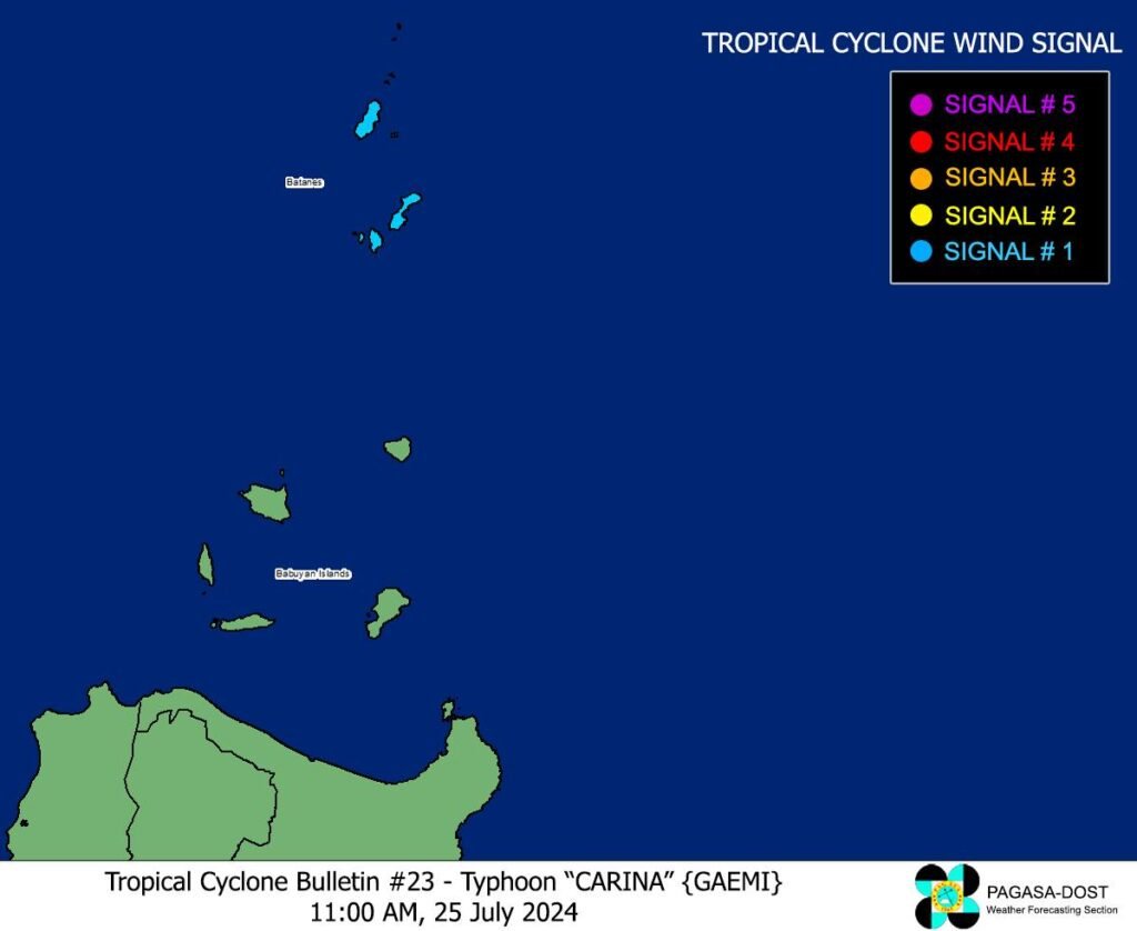
𝐓𝐑𝐎𝐏𝐈𝐂𝐀𝐋 𝐂𝐘𝐂𝐋𝐎𝐍𝐄 𝐖𝐈𝐍𝐃 𝐒𝐈𝐆𝐍𝐀𝐋𝐒 (𝐓𝐂𝐖𝐒) 𝐈𝐍 𝐄𝐅𝐅𝐄𝐂𝐓
𝐓𝐂𝐖𝐒 𝐍𝐨. 𝟏
𝐋𝐮𝐳𝐨𝐧
Batanes
𝐖𝐢𝐧𝐝 𝐭𝐡𝐫𝐞𝐚𝐭: Strong winds
𝐖𝐚𝐫𝐧𝐢𝐧𝐠 𝐥𝐞𝐚𝐝 𝐭𝐢𝐦𝐞: 36 hours
𝐑𝐚𝐧𝐠𝐞 𝐨𝐟 𝐰𝐢𝐧𝐝 𝐬𝐩𝐞𝐞𝐝𝐬: 39 to 61 km/h (Beaufort 6 to 7)
𝐏𝐨𝐭𝐞𝐧𝐭𝐢𝐚𝐥 𝐢𝐦𝐩𝐚𝐜𝐭𝐬 𝐨𝐟 𝐰𝐢𝐧𝐝𝐬: Minimal to minor threat to life and property
𝐎𝐓𝐇𝐄𝐑 𝐇𝐀𝐙𝐀𝐑𝐃𝐒 𝐀𝐅𝐅𝐄𝐂𝐓𝐈𝐍𝐆 𝐋𝐀𝐍𝐃 𝐀𝐑𝐄𝐀𝐒
𝐇𝐞𝐚𝐯𝐲 𝐑𝐚𝐢𝐧𝐟𝐚𝐥𝐥 𝐎𝐮𝐭𝐥𝐨𝐨𝐤
Typhoon CARINA is now less likely to directly bring heavy rainfall over any portion of the country. However, the Southwest Monsoon enhanced by CARINA will bring heavy to intense rainfall over Ilocos Region, Zambales, and Benguet for today while moderate to heavy rainfall over various localities in the western portion of Luzon from today through Saturday. For more information, refer to Weather Advisory No. 31 issued at 11:00 AM today.
𝐒𝐞𝐯𝐞𝐫𝐞 𝐖𝐢𝐧𝐝𝐬
The wind signals warn the public of the general wind threat over an area due to the tropical cyclone. Local winds may be slightly stronger/enhanced in coastal and upland/mountainous areas exposed to winds. Winds are less strong in areas sheltered from the prevailing wind direction.
- Minimal to minor impacts from strong winds are possible within any of the areas under Wind Signal No. 1.
The Southwest Monsoon enhanced by CARINA will also bring strong to gale-force gusts over the following areas (especially in coastal and upland areas exposed to winds): - Today and tomorrow (26 July): Batanes, Babuyan Islands, Ilocos Region, Cordillera Administrative Region, Nueva Vizcaya, Quirino, the eastern portion of Isabela, Central Luzon, Metro Manila, CALABARZON, MIMAROPA, Bicol Region, Western Visayas, Negros Occidental, and Northern Samar
- Saturday (27 July): Batanes, Ilocos Region, Zambales, Bataan, Marinduque, Romblon, and Kalayaan Islands.
𝐇𝐀𝐙𝐀𝐑𝐃𝐒 𝐀𝐅𝐅𝐄𝐂𝐓𝐈𝐍𝐆 𝐂𝐎𝐀𝐒𝐓𝐀𝐋 𝐖𝐀𝐓𝐄𝐑𝐒
- Gale Warning is in effect over the coastal waters of Batanes, Babuyan Islands, Ilocos Norte, Ilocos Sur, and northwestern Cagayan. Sea travel is risky for small seacrafts, including all types of motorbancas. For more information, refer to Gale Warning No. 6 issued at 5:00 AM today.
- In the next 24 hours, CARINA and the enhanced Southwest Monsoon will bring rough seas over the western seaboard of Central Luzon (2.5 to 4.0 m). Moderate to rough seas are also expected over the northern and western seaboards of Northern Luzon outside Gale Warning areas, the western seaboard of Southern Luzon (1.5 to 4.0 m), and the eastern seaboard of Northern Luzon (1.5 to 3.5 m). Mariners of small seacrafts, including all types of motorbancas, are advised not to venture out to sea under these conditions, especially if inexperienced or operating ill-equipped vessels.
- Up to moderate seas are also expected over the eastern seaboards of Central and Southern Luzon, the southern seaboard of Southern Luzon (1.0 to 2.5 m), the western and eastern seaboards of Visayas, and the eastern seaboard of Mindanao (1.0 to 2.0 m). Mariners of motorbancas and similarly-sized vessels are advised to take precautionary measures while venturing out to sea and, if possible, avoid navigation under these conditions.
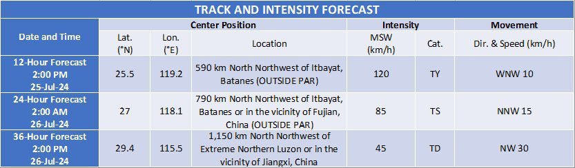
𝐓𝐑𝐀𝐂𝐊 𝐀𝐍𝐃 𝐈𝐍𝐓𝐄𝐍𝐒𝐈𝐓𝐘 𝐎𝐔𝐓𝐋𝐎𝐎𝐊
- Outside PAR region, CARINA will continue to move west northwestward and is forecast to make its final landfall over southeastern China this afternoon or evening.
- Over Taiwan Strait, CARINA will continue to weaken as it further interacts with the mountainous terrain of Taiwan and the landmass of southeastern China.
Considering these developments, the public and disaster risk reduction and management offices concerned are advised to take all necessary measures to protect life and property. Persons living in areas identified to be highly or very highly susceptible to these hazards are advised to follow evacuation and other instructions from local officials. For heavy rainfall warnings, thunderstorm/rainfall advisories, and other severe weather information specific to your area, please monitor products issued by your local PAGASA Regional Services Division.
The next tropical cyclone bulletin will be issued at 5:00 PM today.